Possible Management Strategies and Mapping Flash Floods Vulnerable Hot Spots In Fujairah City – Using Remote Sensing and GIS Based Analysis
Flash floods are the most common natural disasters worldwide. They occur when a large amount of rain falls rapidly, resulting in significant surface runoff. The frequency of flood catastrophes has significantly risen as a result of climate change and other environmental factors. Given the vulnerability of most nations to flooding, it poses a significant global hazard to human life. Flash floods have the potential to do harm in any location, but they are more devastating in proximity to rivers and in areas dedicated to agriculture, infrastructure, and human settlements. Annually, flash floods cause the deaths of around 5000 individuals worldwide. This problem may also be exacerbated by other variables such as drainage density, slope, and inadequate mapping or preventative measures.
A wadi is a dry valley stream commonly found in arid climates, such as countries located on the Arabian Peninsula. Precipitation in Wadis is predominantly sporadic, exhibiting significant temporal and spatial variability, with several years passing without any rainfall. Nevertheless, the frequency and intensity of wadi flash floods in arid regions have recently escalated as a result of climate change. As per the United Nations Office for Disaster Risk Reduction (UNISDR), Arabian countries have experienced numerous disasters in the past three decades, resulting in the loss of more than 150,000 lives and affecting about 10 million individuals.
Flash floods in Oman are often caused by severe occurrences, such as tropical cyclones, which result in significant damage to infrastructure and loss of life. Furthermore, Oman saw significant impact from the devastating tropical cyclone Gonu in July 2007, resulting in 54 deaths and $3.9 billion worth of property destruction. In October 2018, a significant portion of the Middle East, encompassing countries such as Jordan, Kuwait, Qatar, Saudi Arabia, United Arab Emirates (UAE), and Oman, saw extensive devastation as a result of a rise in the occurrence of extreme rainfall events, which in turn led to many flash floods. The floods resulted in fatalities among both humans and animals, as well as extensive damage to critical infrastructure such as dwellings, villages, agricultural grounds, highways, electrical towers, and pipelines. In 2018, the flooding of the Wadi caused over 4000 tourists to evacuate to safer regions just under an hour before the highest level of flooding reached Petra, a historic landmark in Jordan. In the past 20 years, the northeastern area of the UAE, specifically Fujairah, has had a total of 14 floods.
In order to address the water resource problem exacerbated by the growing population and shifting climate in the Arabian Gulf region, nations in the area have made investments in weather modification research and its practical applications. In the past decade, the UAE initiated cloud seeding operations to meet the country's growing water demands, drawing inspiration from global cloud seeding efforts. Upon comparing the time period preceding cloud seeding (before to 2010) with the subsequent period, it was seen that the Hajar Mountains in the eastern region of the UAE experienced a noticeable increase in rainfall intensities.
Considering the aforementioned information, the modeling of flash floods is an essential tool for the management and reduction of floods. In order to mitigate potential property damage and loss of life caused by flash floods, flood control design should take into account the impact of global warming, particularly the risks of flash floods in residential areas. The prevention of this particular natural hazard is not possible, however, it can be effectively managed through the implementation of efficient flood management strategies. These strategies include the collection of floodwater and rainfall runoff for human and livestock consumption, as well as agricultural purposes. Additionally, the construction of underground dams, artificial lakes, recharge dams, and off-stream structures can aid in controlling the impact of floods. Thematic layers such as rainfall, elevation, slope, geology, geomorphology, land use and land cover (LULC), soil, and drainage density were developed and analyzed using weighted overlay analysis in this study. The purpose was to identify locations that are potentially prone to flooding. Flood-vulnerable maps offer local municipalities and individuals' precise information regarding the extent of flood risk in their localities. They can be efficiently employed as a means of guiding evacuations during a flood emergency.
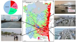
The study employs a comprehensive technique that encompasses the collecting of both spatial and non-spatial data. The spatial data is stored in the database as many layers in digital format, encompassing maps of drainage density, elevation, slope, geology, geomorphology, land use and land cover (LULC), soil, and rainfall. All these layer integrations, queries, analyses, and other operations are conducted inside the framework of a Geographic Information System (GIS). The new maps are built by merging these layers and modifying them to appropriately evaluate the correlations between the selected attributes in the different layers being considered. A map delineating flood-prone areas has been generated by integrating spatial data on rainfall, drainage density, elevation, slope, land use and land cover (LULC), geology, geomorphology, and soil characteristics. The weight value of the parameter is represented as a percentage ranging from 0% to 100%. The class values are assigned a ranking ranging from 1 to 5 based on scientific standards and assumptions, following the calculation of criteria value ranges. The rankings were assigned on a scale of 1 to 5, with 5 denoting the highest level of significance and 1 denoting the lowest level of importance. Due to the presence of mountains exceeding an elevation of 80 meters above mean sea level, about 71.7% of the research region is classified as having a moderate to very low vulnerability. The remaining 28.3% consists of places that are very and very highly vulnerable. This refers to the densely populated, low-lying areas that are situated near the Gulf of Oman in Fujairah City. These areas have expanded into geographically vulnerable regions that are susceptible to sudden and intense floods. The gradual expansion of urbanized regions in the Fujairah City region leads to the growth of impermeable infrastructure, resulting in less water absorption and increased surface runoff after heavy rainfall occurring within a short timeframe.
By closely monitoring locations that are prone to flooding, the chances of flooding occurring can be reduced. Flood mitigation measures can be categorized into two approaches: non-structural and structural. Non-structural measures encompass strategies that do not involve engineering interventions. These include activities like enhancing preparedness through early warning systems, regulating land use and development, and effectively planning and operating flood control reservoirs. Specialized strategies tailored to specific ecosystems, such as the restoration of natural conditions or the implementation of conventional barriers like dams and levees, can serve as effective structural defense tactics. These tactics play a vital role in mitigating the risks posed by hazardous floods and facilitating water management. To effectively reduce the occurrence of local floods in Fujairah, it is crucial to implement the development approach known as "Sponge City". The Sponge City is designed according to natural and ecological principles, enabling the effective management of storm water and flood water through natural processes such as infiltration, retention, detention, and cleaning facilities. During rainfall, the city will assimilate, retain, permeate, and cleanse the water as needed. Hence, it is imperative to prioritize water conservation and systematically advance the development of sponge cities, ensuring a harmonious allocation of resources.